
Hanover Park ZIP Coverage Evidence
Official evidence supports 60133 as Hanover Park's primary current delivery ZIP. Other numbers appear in old village material or USPS container and label tables, but those relationships are not proof of present street-level service. A sound postal guide must keep delivery coverage, historical labels, and postal logistics separate. USPS address lookup remains the authority for one street and unit.
| ZIP Code | Areas Covered | Post Office | Notes |
|---|---|---|---|
| 60133 | Hanover Park primary current delivery label | Hanover Park label in USPS evidence | Not a legal village polygon |
| 60103 | Older Hanover Park material and current Bartlett label | Shared before the 2001 change | Historical clue, not current proof |
| 60107 | USPS label-container relationship | Bensenville label in cited table | Current Hanover Park coverage not verified |
| 60184 | Destination in a USPS logistics table | Container relationship shown | Not geographic delivery evidence |
| 60185 / 60186 | Historic West Chicago routing relationships | 2018 USPS bulletin evidence | Not current Hanover Park ZIPs |
| 60172 | Four older deliveries changed to 60133 | Roselle history in 2009 bulletin | Change clue only |
No official citywide USPS polygon, ZIP-level population count, PO-box-only ZIP, or unique-institution ZIP was verified for Hanover Park. Those gaps should remain visible. Adding another number from a logistics table would turn routing evidence into a false coverage claim.
Hanover Park 60133 Postal Shift
A village notice says Hanover Park gained its own 60133 ZIP effective July 1, 2001 after sharing 60103 with Bartlett. The USPS 2001 Postal Bulletin also describes the new delivery area. This is more than local trivia. A deed, phone directory, school item, newspaper notice, or family letter from before the change may pair a recognizable Hanover Park street with Bartlett and 60103.
Search both postal forms when tracing an older person or address. Keep the record's original city and ZIP in notes, then add a separate current USPS verification. Do not silently rewrite an old source to 60133. The old label helps date the trail and can explain why a strict modern search returns no match.
Note: The postal change date is a search aid, not proof that every address changed on the same record system at once.
Verify Hanover Park ZIP Addresses
The USPS ZIP Lookup offers address-to-ZIP, city-and-state-to-ZIP, and ZIP-to-city modes. Enter the full street number, direction, street type, and unit. Save the standardized output and date. USPS warns that a returned ZIP does not confirm that a person or company occupies the address.
| Search mode | Use in a ZIP code lookup | Limit |
|---|---|---|
| Address | Verify one street and unit | Does not prove occupancy |
| City and state | Find postal ZIP labels for a locality | Does not draw city limits |
| ZIP to city | Check the USPS preferred label | Label may differ from municipal identity |
| AIS address products | Monthly maintained postal data | No public legal-boundary polygon |
A Hanover Park ZIP search becomes stronger when the postal result is paired with the village and county systems. Use the village map for municipal context, then use a parcel identifier to reach the correct assessor or GIS record.
Keep the standardized postal line separate from the land-record line. Cook commonly identifies parcels with a 14-digit PIN, while the DuPage sample format uses ten digits. County parcel systems may also display a property address, a tax-bill mailing address, a municipality, a township, and district fields. They answer different questions. The USPS result confirms how mail should be labeled. The PIN identifies a unit of land. The tax mailing address shows where the bill is sent, not who occupies the parcel. Saving each field under its original label prevents a ZIP code search from turning a billing clue into an unsupported resident claim.
Find Hanover Park Residents by ZIP
No verified official portal returns every person in a Hanover Park ZIP. ZIP is a narrowing field, not a resident roll. The practical method moves from a postal address to county jurisdiction, then to the official record that answers the question. Property systems are strongest when given an address or PIN. A PIN is a parcel identification number.
- Standardize the complete street address and unit through USPS.
- Use the village map to identify municipal, county, and township context.
- Search Cook or DuPage property tools by address, then save the PIN.
- Use the official voter-status route or county office only within Illinois access limits.
- Confirm any named result with a date, role, parcel, or second official record.
DuPage Property Lookup offers parcel, address, billing-name, map, and hearing modes. Cook's Property Portal, Assessor tools, and CookViewer accept address, PIN, parcel, map, or intersection inputs depending on the portal. None is a verified search for all residents in 60133. Once the ZIP is narrowed to a road, the Hanover Park street directory follows the address-level record chain.
Map Hanover Park ZIP Context
The village Maps page accepts an address through its community portal and links street, township, zoning, school, bike, and land-use maps. It is the right orientation layer when a postal label conflicts with county or service-area clues.
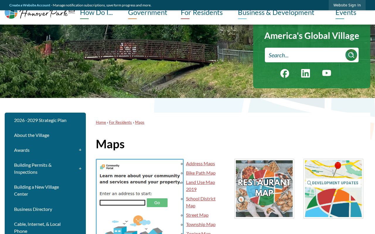
The village map screen helps place an address within local service geography. It does not publish a complete numbered-address list, assign postal labels, or replace the county parcel record.
Hanover Park addresses may route through Wayne or Bloomingdale townships on the DuPage side and Hanover or Schaumburg townships on the Cook side. The exact address should decide. Roads and village service zones are useful visual clues, but only the responsible agency can settle a conflict in the field it created.
Village history explains why these layers are not neat. Hanover Park incorporated in 1958 with its original boundaries on the Cook side. About 750 acres of DuPage farmland were annexed in 1969, and Ontarioville joined the village in 1982. Greenbrook developed in the 1960s, followed by Woodlake Trails and Olde Salem in the early 1970s. An older directory, deed, or newspaper may therefore use a township, subdivision, nearby postal town, or pre-annexation place name even when the modern address is associated with Hanover Park and 60133.
The village's hydrant-flushing map adds practical orientation zones around Irving Park Road, Lake Street, Barrington Road, Stearns Road, and Schick Road. Those service divisions can help place a street on the Cook or DuPage side before opening a county portal. They are operational zones, not postal polygons, parcel lines, or proof of municipal jurisdiction.
Read Hanover Park ZIP Tables
Postal Bulletin tables often describe container and label relationships used in mail processing. They are not lists of neighborhoods served by each ZIP. The 2024 USPS label table connects numbers such as 60107 and 60184 with Hanover Park 60133 in routing rows. That evidence is valuable only when described as logistics.
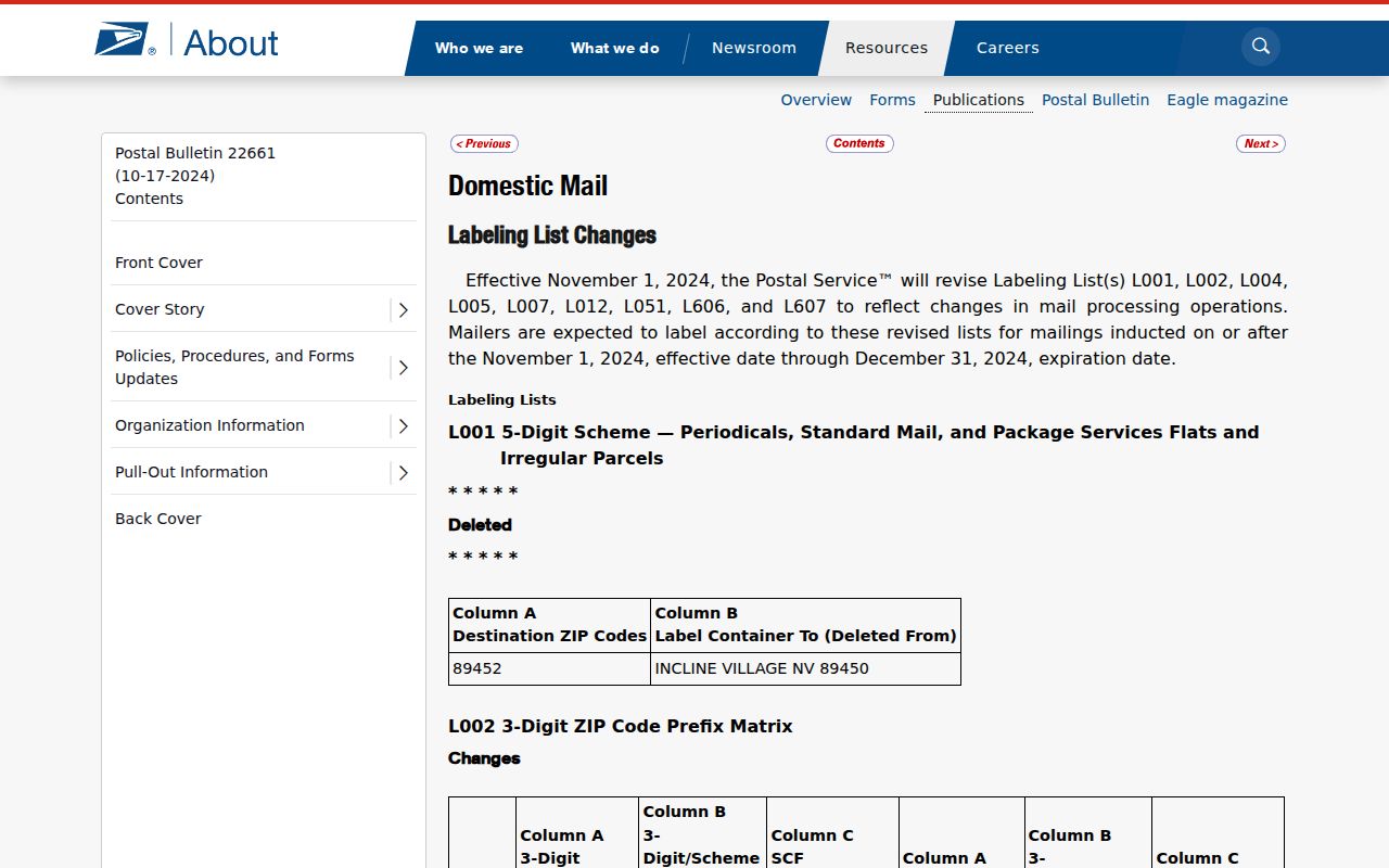
The screenshot shows the official table format behind those relationships. It does not establish that a Hanover Park resident receives mail under every number shown.
Postal myth. A ZIP in a container row is not a boundary claim. Verify the exact address in USPS before using it in resident research.
Move Beyond Hanover Park ZIP
ZIP labels can change, while a parcel's legal description often remains a better bridge. DuPage sample PINs use ten digits. Cook commonly uses fourteen digits, sometimes displayed with dashes. County GIS layers also distinguish the property or situs address from the billing address. Situs means the address of the parcel itself; billing is where the tax notice is sent.
Use the ZIP code directory to reach the right parcel, then retain the PIN, subdivision, lot, block, and legal description. Those keys can connect assessor data, deeds, tax history, and maps without assuming that the postal city is the legal village or that the tax-bill recipient lives at the site.
Hanover Park ZIPs Versus Limits
USPS assigns delivery labels, while Hanover Park maintains municipal maps and planning context. Cook and DuPage maintain parcels and tax identifiers. Election, school, library, park, and township agencies apply still more boundaries. These layers can disagree without any one record being wrong. A 60133 mailing line is therefore not proof that the parcel lies inside Hanover Park or in a particular county.
When fields conflict, ask the agency that created each one. USPS settles the postal line. The village settles municipal map questions. The county assessor or GIS office settles the parcel key. The election authority settles precinct and registration routing. Preserve both values and the date instead of forcing every system to use one city label.
Other official systems reinforce the same limit. Village permits and code matters key records to a site address. Deeds use recorded names, a PIN, and a legal description. Historical reverse directories use the street and publication year. Voter files distinguish residence and mailing fields under Illinois access restrictions. School, library, park, and tax districts follow their own geography. None of these systems was verified as an official tool that returns all residents within 60133, and no official ZIP-level population or registration count was located.
When research moves from a ZIP to a person, retain the full address and unit, then verify the county before selecting a roll. When it moves backward in time, search 60133 and the earlier 60103 or Bartlett label without rewriting the original source. This keeps the ZIP-only role clear: postal evidence narrows and standardizes an address, while the proper custodian supplies the parcel, voter, permit, deed, or historical record.
- ZIP vs ZIP+4
- A five-digit delivery area versus a more precise four-digit add-on for a delivery segment.
- PO-box ZIP
- A ZIP assigned mainly to post-office boxes rather than ordinary street delivery.
- Unique ZIP
- A ZIP assigned to one high-volume organization. None was verified for Hanover Park.
- Carrier route
- A group of delivery points served along one postal route, not a city boundary.
That distinction is the core limit of every Hanover Park ZIP code lookup. It narrows the place. It does not establish a household, parcel owner, voter, or municipal jurisdiction by itself.